The Dalles Unit: IFPL 3 to be in effect for MH-1 July 29, 2016

https://geo.maps.arcgis.com/apps/webappviewer/index.html?id=41424358763949deb16e3f513e748844
Click Map for Statewide Current Fire Restrictions
STATE OF OREGON
DEPARTMENT OF FORESTRY
INDUSTRIAL FIRE PRECAUTION LEVEL 3
CLOSEDOWN ORDER

Number 03

Effective 12:01 a.m., PDT, July 29, 2016

By virtue of the authority vested in me by ORS 477.625, ORS 477.670, and OAR 629-043-0070, I hereby issue notice the following subject area is susceptible to damage by fire and proclaim Industrial Fire Precaution Level 3 to be in effect:

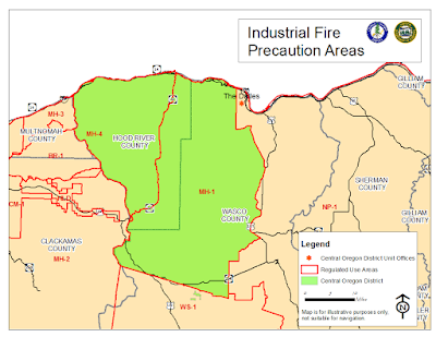
All lands protected by the Central Oregon Forest Protection District, in regulated use area MH-1 and all forestland within one-eighth mile thereof.
Under Industrial Fire Precaution Level 3, the use of fire or power-driven machinery in any operation area is unlawful unless such use is in compliance with the following:
Partial Shutdown: The following activities are not permitted at any time, except as noted:
  1. Cable yarding systems, except that gravity operated logging systems using non-motorized carriages may operate between 8:00 p.m. and 1:00 p.m., when all blocks and moving lines are suspended at least 10 feet above the ground (except the line between the carriage and the chokers).
  2. Power saws, except power saws may operate at loading sites and on tractor or skidder operations between 8:00 p.m. and 1:00 p.m.
In addition, the following activities are permitted to operate between 8:00 p.m. and 1:00 p.m. local time:
  1. Tractor, skidder, feller-buncher, forwarder, or shovel logging operations where  tractors, skidders, or other equipment with a blade capable of constructing a fireline are immediately available to quickly reach and effectively attack a fire start.
  2. Mechanized loading or hauling of any product or material
  3. Blasting, welding or cutting of metal
  4. Any other spark emitting activity not specifically mentioned.
The State Forester or an authorized representative may, in writing, approve a modification or waiver of these requirements.

These restrictions shall remain in effect until replaced or terminated by an additional Closedown Order of the State Forester or an authorized representative.

Maps of the subject area may be viewed at the State Forester's Office, in Salem, Oregon, and at principal offices of the Forest Protection District.

Definitions of words and phrases used in this proclamation may be found in ORS 477.001, OAR 629-041-0005.

MH-1 and MH-4 Industrial Fire Precaution Level 2 as of July 25, 2016

Link to Statewide Fire Restriction Map
Click map for statewide map of current fire restrictions.

STATE OF OREGON

DEPARTMENT OF FORESTRY

INDUSTRIAL FIRE PRECAUTION LEVEL 2

CLOSEDOWN ORDER

 Number 02
 
Effective 10:00 a.m., PDT, July 25, 2016

By virtue of the authority vested in me by ORS 477.625, ORS 477.670, and OAR 629-043-0070, I hereby issue notice the following subject area is susceptible to damage by fire and proclaim Industrial Fire Precaution Level 2 to be in effect:

All lands protected by the Central Oregon Forest Protection District, in regulated use areas MH-1 and MH-4 and all forestland within one-eighth mile thereof.
                                                        
Under Industrial Fire Precaution Level 2, the use of fire or power-driven machinery in any operation area is unlawful unless such use is in compliance with the following:

Partial Shutdown: The following activities are not permitted between the hours of 1:00 p.m. and 8:00 p.m., except as noted:

1.     Power saws, except power saws may operate at loading sites.
2.     Cable yarding
3.     Blasting
4.     Welding or cutting of metal

The State Forester or an authorized representative may, in writing, approve a modification or waiver of these requirements.

These restrictions shall remain in effect until replaced or terminated by an additional Closedown Order of the State Forester or an authorized representative.

Maps of the subject area may be viewed at the State Forester's Office, in Salem, Oregon, and at principal offices of the Forest Protection District.

Definitions of words and phrases used in this proclamation may be found in ORS 477.001, OAR 629-041-0005.

Limited Moisture Not Enough to Reduce Fire Danger

While central Oregon is in a pattern of cooler than normal weather, and has received precipitation over the last twenty-four hours, fire danger remains high.  The US Drought Monitor for Oregon issued on July 7, 2016, indicates that most lands within the Central Oregon District (COD) fall into the “abnormally dry” category.  This reflects what fire managers are seeing in the forest and current fuel moisture conditions.  Now into Oregon’s fifth year of drought conditions, we continue to see the long term affects to the down material and live vegetation stressed from limited water.

For the next few days firefighters will benefit from the moisture, because it will be more difficult for a “spark” to ignite a fire and rapidly spread.  This is because of the increased moisture in the fine fuels, but these fuels will quickly dry out even with the moderate temperatures expected over the next few days.  “The biggest concern for us now, during the heart of fire season, is that someone assumes the rain has made it safe to burn.  When surrounding fuels dry out in the days following a debris burn, the remnants of that debris burn rekindle and spread to wildland fuels while no one is watching”, states Mike Shaw, Central Oregon District Forester. 

Debris burning is not allowed on lands protected by the Central Oregon District of the Oregon Department of Forestry.  Contact information for your local ODF Office can be found on ODF’s Central Oregon District website: www.ODFcentraloregon.com. 

COD remains in a Regulated Use Closure intended to reduce human caused fires.  Year to date there have been thirty-six human caused fires within the District, primarily related to debris burning.  This number is significantly higher than the ten year average of twenty-eight (for the same time period).  These fires are preventable, causing concern for firefighters and fire managers.  While fire managers have the ability to use modern technology to track thunderstorms and staff with additional resources, human caused fires do not allow that as they occur at random times. 

Please report fires to your local 911 dispatch center.

Wassen Fire Pond Update | July 5, 2016

[The Dalles Unit, Central Oregon District] - The Wassen Pond Fire was reported at about 7:30 p.m. on Sunday, July 3, burning four miles west of The Dalles on lands protected by the Oregon Department of Forestry and Mid-Columbia Fire and Rescue.

The fire remains at 300 acres this morning (about 30 acres on ODF jurisdiction) and is 75 percent contained. Line construction will continue today to fully contain the fire.

The fire is under Unified Command between ODF and MCFR. Cause remains under investigation.

Wassen Pond Fire

 [The Dalles Unit, Central Oregon District] - The Wassen Pond Fire was reported at about 7:30 p.m. on Sunday, July 3, burning four miles west of The Dalles on lands protected by the Oregon Department of Forestry and Mid-Columbia Fire and Rescue.  The fire, under Unified Command between ODF and MCFR, is currently approximately 180 acres (with most of that acreage on MCFR), and hand- and dozer-lined.  Additional resources from ODF, rural fire departments in the area, and the Columbia River Gorge National Scenic Area are assisting with this fire.  Cause of the fire remains under investigation.

Fire officials in the Columbia River Gorge urge the public to be extremely cautious and wildfire-safe, particularly with fireworks, as firefighting resources are stretched thin in the area and a Red Flag Warning for high winds and low humidity is in effect.
 
Published from the Oregon Department of Forestry Daily Fire Update | Monday, July 4, 2016